FEATURED REGENCY WORLD ARTICLES:
French Evening Dress, May 1799
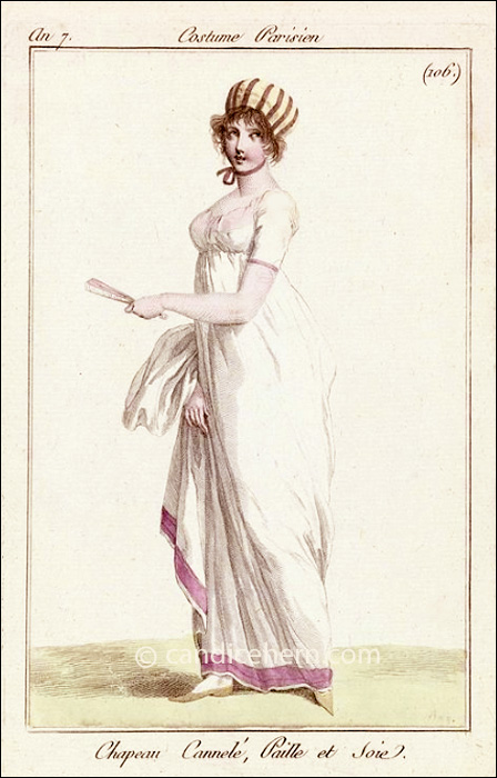
The dress is quite simple, very much in the neo-classical style. The only ornamentation is the pink trimming... Read More →
Portable Writing Set

This favorite item from my collections is a miniature portable writing set, c1770. The tiny tortoiseshell box measures only 2½” by 1½” — so small it might have easily been carried in a lady’s reticule. It is lined in red velvet, and all the fittings are sterling silver. Inside is everything needed to pen a quick note, perhaps when traveling or otherwise away from pen and ink. As you can see in the image below, there is a tiny ink bottle and matching pounce bottle, with remnants of ink and pounce in each. (Pounce is a finely ground powder made of fine sand or a powdered mineral, such as sandstone or talc, sprinkled over wet ink to hasten the drying.) A clever articulated... Read More →
Regency in General
Links to various general sites on the Regency, many with lots more sub-links to more detailed Regency... Read More →
Subscribe to the Regency World
Get Regency World updates brought to you via an RSS reader or straight into your email inbox.
In Your Inbox

Candice is a passionate collector of Georgian and Regency period antiques, and shares many of her collections here on this site, including fashion prints, fans, jewelry, silhouettes, perfume bottles, and many others. She also shares items from her collections on Instagram. Follow her!
What is the Regency?
The English Regency, in its most literal interpretation, encompasses the years 1811 to 1820. It was the time during which the Prince of Wales (who later ruled as George IV) served as Regent while his father George III was so mentally unbalanced as to be unable to serve as monarch. In its broader interpretation — when used to describe periods of art, literature, fashion, design, and architecture — the Regency can encompass years as early as 1790 and as late as 1830.
The Regency as a setting for romance is appealing in great part due to the rich dichotomy of society vs. history, the real world vs. the oblivious aristocratic fantasy world. It is that small, glittering, elegant world seemingly insulated from the horrors of the Napoleonic Wars, the beginnings of political, social, and agricultural reform, and the onset of the industrial revolution that provides a very real and complex backdrop for Candice’s novels. While the war ravaged the Continent and affected most English families through the loss of sons, husbands, fathers, brothers, and uncles, and while the Luddites rioted against industrialization, Society persevered in its elegant finery at balls and routs and parties of all kinds.
You are invited to ENTER THE REGENCY WORLD through the menu on this page, where you will learn more about the people, the places, the fashion, the language, and more. Not sure where to start? Try this page.
Have fun exploring!